Munich neighborhood map
You can find on this page the Munich neighborhood map to print and to download in PDF. The Munich districts map presents quarters, region, suburbs and surrounding area of Munich in Bavaria - Germany.
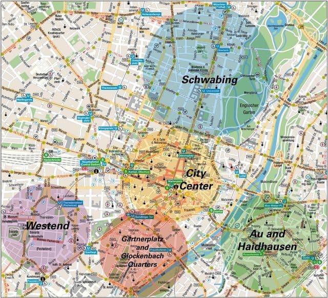
Munich neighborhoods map
The Munich neighborhoods map shows region and suburbs of Munich areas. This neighborhood map of Munich will allow you to discover quarters and surrounding area of Munich in Bavaria - Germany. The Munich quarters map is downloadable in PDF, printable and free.
The bohemian neighbourhood of Schwabing is just to the north of Maxvorstadt, and also borders the Englischer Garten. The Countess of Schwabing, Franziska zu Reventlow, once stated, “Schwabing is not a neighbourhood, but a state of being”, and despite gentrification, the free-spirited district retains its charm. Schwabing as you can see in Munich neighborhoods map, even more so than Maxvorstadt, was a hotspot for artists and writers in the early 1900s. Wassily Kandinsky, Thomas Mann, Rainer Maria Rilke and even Lenin lived in the district at the turn of the century. Now, the bustling district is popular with Munich young people, and it is become one of the city most expensive and coveted areas to live in. The vibrant, pretty neighbourhood of Glockenbachviertel is right next to Munich river Isar, and attracts a young, hip crowd. It is particularly welcoming to Munich LBGTQ community, with plenty of gay bars and clubs to be found along Müllerstraße. The epicentre of Glockenbachviertel is the Gärtnerplatz, a piazza teeming with flowers. The roads that shoot off it are full of cool cafes and trendy bars, as well as shops selling independent labels. If you are planning on partying during your visit to Munich, stay in one of the many hotels in this area.
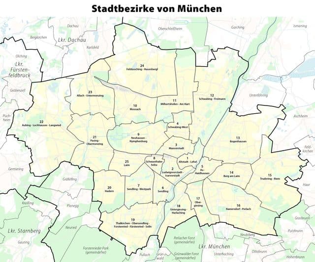
Munich districts map
The Munich districts map shows all quarters and suburbs of Munich. This district map of Munich will allow you to discover areas and the region of Munich in Bavaria - Germany. The Munich districts map is downloadable in PDF, printable and free.
The city of Munich is politically and administratively divided into 25 districts as you can see in Munich districts map. The names of the districts are largely familiar to Munich residents, as they usually correspond to the traditional names of the city districts. The first district is the Altstadt (Old Town), the districts around the city centre have low numbers. The high double-digit districts are the suburbs, which are located on the outskirts of the city. The numbers of the districts are rather unknown in Munich. Old town and Lehel: Comprises mostly the parts of Munich that are called the city centre and the quarter Lehel that is located a little north of it. In the city centre there are many sightseeings and the central shopping streets. The Lehel is an expensive and rather quiet inner city residential area. It is the most expensive district in Munich, especially the purchase and rent of real estate is very expensive here. For the tourist a hotel in this district is ideal.